No Warnings, Watches, or Advisories

NWS North Mississippi Valley Regional Radar WU Central Satellite
Radar/Satellite images courtesy of NOAA/NWS and Weather Underground.
spacer
METRIC | IMPERIAL
Updated: 16-May-2024 @ 11:20pm   (0 sec ago)
Temperature Current Conditions Forecast / Storm Prediction
Currently Outside: Colder 0.5°F than last hour.

65.2°F

---
High Today
71.9°F
17:08
Low Today
61.9°F
05:59
Yest High
72.5°F
15:31
Yest Low
60.6°F
06:18
Sta* High
88.2°F
2019
Sta* Low
39.4°F
2014
* This Station's Records Since 1/2007
Rec* High
78.1°F
2007
Rec* Low
3.9°F
0
* Records from Weather Underground
Clear Clear

Calm Wind:  SE
0.0

Gusting to:
0.0 mph
Current Rain Rain:
0.09 in
Fire Weather Index: MINIMAL Current FWI:4
Fire Danger:
0.0 of 232
Tonight

Tonight: Mostly Cloudy then Patchy Fog
Mostly Cloudy then Patchy Fog
Friday

Friday: Patchy Fog then Slight Chance Showers And Thunderstorms
Patchy Fog then Slight Chance Showers And T-Storms
Friday
Night
Friday Night: Mostly Clear
Mostly Clear
Lo 58°F Hi 76°F Lo 58°F

Click here for full Forecast
SPC Activity Map
Dew Point Liquid Precipitation Wind Speed Sun/Moon
Current: Decreased 0.9°F since last hour. 50.0°F
Last Hour: Decreased 0.9°F since last hour. 0.9°F
High 16:43: 62.2°F
Low 06:41: 46.4°F
Record High: 91.2°F on
5-Aug-2008
Record Low: -16.2°F on
14-Jan-2024
Wetbulb: 57.1°F
Leaf Wet:7 15
Rain Today
rain graph

Today: 0.09 in
Storm Rain: 0.08 in
Yesterday: 0.00 in
Last 7 Days: 1.02 in
May Rain: 2.47 in
May to Date
  Avg:10
0.00 in
May to Date
  Diff from Avg:10
Over 2.47 in for the month 2.47 in
May Avg: 2.25 in
Diff from Avg: Over 0.22 in for the month 0.22 in
Season:1 13.75 in
YTD
  Avg:11
7.90 in
YTD
  Diff from Avg:11
Over 5.85 in for the year 5.85 in
Last Rain
Time/Date:
5-UNK-2024
at 20:12
47 rain days in 2024
10 days in May
0 days since last rain
Current: SE  0.0 mph
1Hr Average: Calm
Wind Run: 0.00 miles
Wind Gust
Current: 0.0 mph
Today: 4.0 mph 07:46
Month: 19.0 mph 14-May
Year: 27.0 mph 8-Feb
Record Gust: 71.3 mph
17-Mar-2009
Sunlight:
14 h 12 m 58 s
of Sunlight Yesterday
14 h 14 m 35 s
of Sunlight Today
Which is
1 min 37 sec longer than
yesterday
14 h 16 m 9 s
of Sunlight Tomorrow
(Noon) graph (Midnight)
Legend

Waxing Gibbous
Waxing Gibbous, 9 days, 1 hours, 0 minutes in cycle
66%
Illuminated
Humidity Barometer
Current: Decreased 1% since last hour. 58%
Last Hour: Decreased 1% since last hour. 1%
High 15:31: 73%
Low 12:07: 52%
Record High: 100%
5-Aug-2008
Record Low: 0%
18-Jun-2008
Current: Rising 0.001  inHg/hr 29.749 inHg
Last Hour: Steady
High 01:10: 29.831
Low 20:39: 29.700
Record High: 31.007 inHg
28-Oct-2007
Record Low: 27.513 inHg
8-Feb-2009
Cooling Degree Days Snow3 Heat Index Air
Today: 0.3
May: 15.7
2024 to Date: 58.4
Heating Degree Days
2024 to Date: 2360.7
Today: 0.00 in
Yesterday: 0.00 in
May Snow: No Change 0.00 in
May Avg: 0.00 in
Diff from Avg: 0.00 in
Season Total:2 0.25 in
Snow Depth: 0.25 in
0 snow days in May
1 snow day this season.2
First Snow of Season:
12-UNK-2023
Average 1st Snow:
19 of Dec
Current: 65.2°F
High 5:08pm: 71.9°F
Yesterday: 72.5°F
Record: 138.2°F
5-Aug-2008
Quality
Index6:

N/A


No Data
Density:
1.20 kg/m3
UV Summary/Forecast Solar Summary
May-16

9.1
May-17

8.7
May-18

7.8
High Today:  
791 W/m2 @ 13:00
Sun Hours Today:
00:00
   This Month: 00:00 Hrs
Rise: 05:53  Set: 20:14
Soil Conditions8 Irrigation Index5 Station All Time Records Outlook
0.4 in: 200.0 cb | 63°F
1 in: 96.0 cb | 63°F
1.8 in: 98.0 cb | 63°F

Growing conditions
at the depth of:  0.4 in:


Soil moisture range is from
0-Wet to 200-Dry/Frozen
Updated at Midnight
Current ET: 0.04 in
7-Days Rain: 1.02 in
7-Days ET: 0.00 in
7-Day:  1.02 in water in excess of what evaporated in last 7 days. 1.02 in
May:  2.47 in water in excess of what evaporated this month. 2.47 in
Cloud Height: 3469 ft
HIGHS: LOWS:
106.2°F
7-Jul-2012
-100.1°F
6-Feb-2007
Daytime Records
  104.0°F°F
28-Jun-2012
  -4.0°F°F
14-Jan-2024
Nitetime Records
  99.3°F°F
14-Jul-2008
  -6.0°F°F
23-Dec-2022
ICN:13 | S3C2:6 | Ajax 3.xx
ISS:Ok | CON:4.5 | RCP:99%
Friday

Friday: Patchy Fog then Slight Chance Showers And Thunderstorms
Patchy Fog then Slight Chance Showers And T-Storms
METRIC | IMPERIAL
Updated: 16-May-2024 @ 11:20pm  
1 Rain season: Jan 1st to Dec 31st.   2 Snow season November 1st to April 30th.   3 Snow manually measured usually around 7AM and 7PM.   4 Updated at Noon Central Time.   5 Estimated amount of water needed to replace the water used by plants and evaporation from the past week. (Negative numbers mean amount of water needed, positive numbers mean excess water is present).   6 Air Quality Index is provided by Minnesota Polution Control Agency and is updated hourly between the hours of 6AM and Midnight.   7 Leaf Wetness is surface moisture on foliage. 0 being totally dry and 15 being totally saturated.   8 Soil moisture and temperatures are from sensors burried in the ground at the levels specified.   10 Historical average only to day 16 of just the month of May for this station since 2007.   11 Historical average rain this season to day 16 of May for this station since 2007.
 NWS Weather Forecast  -   Outlook Tonight & Friday
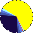
Tonight

Tonight: Mostly Cloudy then Patchy Fog
Mostly Cloudy then Patchy Fog

Lo 58°F
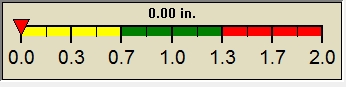
NWS forecast: Patchy fog after 3am. Mostly cloudy, with a low around 58. Southwest wind around 3 mph.
WXSIM forecast: Mostly cloudy to cloudy in the evening, becoming partly to mostly cloudy after midnight. Patchy light fog in the evening, then light to moderate fog after midnight. A slight chance of rain. Scattered thundershowers possible. Low 62°. Wind west-southwest around 3 mph. Chance of precipitation 20 percent. Precipitation mostly less than a tenth of an inch.
Local station forecast: Mostly cloudy. Patchy fog. Lows in the upper 50s. Southwest winds around 5 mph.
Friday

Friday: Patchy Fog then Slight Chance Showers And Thunderstorms
Patchy Fog then Slight Chance Showers And T-Storms

Hi 76°F
NWS forecast: Patchy fog before 8am, then a slight chance of showers and thunderstorms. Mostly sunny, with a high near 76. East wind 1 to 6 mph. Chance of precipitation is 20%.
WXSIM forecast: Mostly cloudy. Patchy light fog in the morning. A slight chance of rain in the morning, then a chance of rain in the afternoon. Scattered thundershowers possible. High 75°. UV index up to 5. Wind east-northeast around 2 mph in the morning, becoming southeast in the afternoon. Chance of precipitation 40 percent. Precipitation mostly less than a tenth of an inch.
 NWS Short Term Weather Forecast
Friday
Night
Friday Night: Mostly Clear
Mostly Clear
Saturday

Saturday: Sunny then Slight Chance Showers And Thunderstorms
Sunny then Slight Chance Showers And T-Storms
Saturday
Night
Saturday Night: Slight Chance Showers And Thunderstorms then Mostly Clear
Slight Chance Showers And T-Storms then Mostly Clear
Sunday

Sunday: Sunny
Sunny
Sunday
Night
Sunday Night: Partly Cloudy
Partly Cloudy
Monday

Monday: Chance Showers And Thunderstorms
Chance Showers And T-Storms
Monday
Night
Monday Night: Chance Showers And Thunderstorms
Chance Showers And T-Storms
Lo 58°F Hi 82°F Lo 61°F Hi 86°F Lo 65°F Hi 85°F Lo 66°F
ajax-dashboard6.php - Version 6.95e - 01-Feb-2022 - Script by: Scott of BurnsvilleWeatherLIVE.com
Now supported by Saratoga-weather.org Download